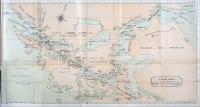
| Title: | Track Chart of the Straits of Magellan |
| Publisher: | Liverpool : Philip Son & Nephew |
| Issue Date: | 1907 |
| Part of: | bbm/3801 |
| General Contents: | Passagem do Oceano Atlântico para o Oceano Pacífico pelo Estreito de Magalhães. Ilustra o livro de Fredereck Alcock que apresenta as condições e as potencialidades econômicas da América do Sul. |
| Type: | Mapa |
| Language: | Inglês Espanhol |
| Subject: | MAPAS DESCRIÇÃO E VIAGENS |
| Geographical Coverage: | ESTREITO DE MAGALHÃES ARGENTINA CHILE AMÉRICA DO SUL |
| Appears in Collections: | Mapas |
Files in This Item:
| File | Description | Size | Format | |
|---|---|---|---|---|
| 01728_MAPA_006.jpg | 717,05 kB | JPEG |  View/Open |
Items in DSpace are protected by copyright, with all rights reserved, unless otherwise indicated.