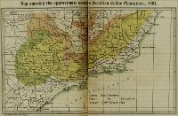
| Title: | Map shewing the approximate extent of the Brazilian Coffee Plantations, 1901 |
| Publisher: | Liverpool : Philip Son & Nephew |
| Issue Date: | [s.d.] |
| Part of: | bbm/3801 Trade and travel in South America |
| Description: | Legenda: a área na cor verde representa as novas plantações de café, a cor pink representa as plantações espalhadas pela região sudeste, e a cor amarela a área das plantações de café em 1892 |
| General Contents: | Mapa apresenta a extensão aproximada da plantação de café na Região Sudeste, em 1901. Ilustra livro de Fredereck Alcock, que apresenta as condições e as potencialidades econômicas da América do Sul. |
| Type: | Mapa |
| Language: | Inglês |
| Subject: | CONDIÇÕES ECONÔMICAS MAPAS |
| Temporal Coverage: | Século 20 |
| Geographical Coverage: | BRASIL REGIÃO SUDESTE SÃO PAULO |
| Appears in Collections: | Mapas |
Files in This Item:
| File | Description | Size | Format | |
|---|---|---|---|---|
| 01728_MAPA_001.jpg | 844,56 kB | JPEG |  View/Open |
Items in DSpace are protected by copyright, with all rights reserved, unless otherwise indicated.